Seabreeze on June 23, 2003
South Portland, Maine Weather Sensors
At around 1:15PM, a very distinct line of fog and a layer of stratus ("a wall of clouds") moved inland from the ocean obscuring the sun and substantially reducing visibility. The apparent humidity was high, and there was some very light surface misting occurring. The Fog and Stratus broke about 2 hours later. It appeared that the moisture from the fog was advected upward, inland, into a deck of stratocumulus that hung around until at least shortly after sunset.
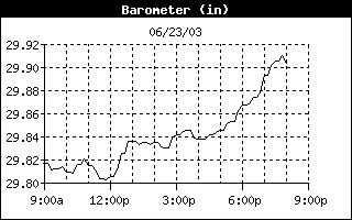 |
Barometer Jump begins at 12:00 Noon and rises from 29.805" to 29.836" at 12:50PM. The barometer is mostly steady for several hours after the Seabreeze front passage, then rises slowly into the evening.
|
|
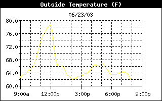 |
The temperature drops from 78.5°F at Noon to 66.8°F at 12:50PM; the temperature dropped almost 10 degrees F in the first 1/2 hour of the passage. Unlike the Barometer, the temperature keeps dropping, and ends up at 63.1°F at 1:40PM. Overall change is 11.7°F in 1 hour and 40mins. |
|
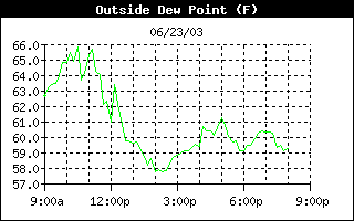 |
Dewpoint drops a bit earlier than the rest. It fluctuated around 65°F 1 hour preceding the event, and dropped 5°F in two hours. The dewpoint delta for this event is about 6°F The relative humidity jumped by 10% right after the frontal passage. |
|
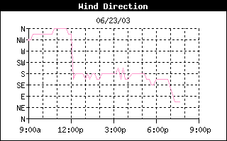 |
Definite wind shift from N and NNW to SSE and S. The winds were Northerly all morning long, then S or SSE after the seabreeze front passage. | |
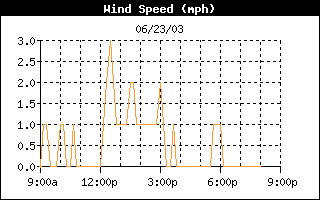 |
Graph shown to left is wind speed; the local topography affects wind speeds, so wind gust is used in this example. Wind (gust) picks up from 2 mph (during the hour preceding) to 6 mph during the hour following the sea breeze front passage. There is a marked increase in the overall wind speed as indicated by the graph. |
|
|
|
||


