Welcome to WeatherMaine
Welcome to WeatherMaine

The original WeatherMaine archives have been copied into articles under the category "Weather Stories".
![]()

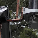
Anemometer is about 42" from the upside-down T adapter.
Design minimizes heat from the roof and exposes to more wind currents, helping the passive radiation shield.
Design also makes servicing unit easy without having to remove the whole mounting. The ISS post enables one to simply loosen the u-bolt and slide it over the small post- without having to unhook the anemometer.
The mounting must be plumb in all directions and care should be given to the installation process to insure the instruments are plumb and balanced.
Parts Needed

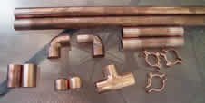
2" copper pipe; two sleeves are shown far lower left, then pipe caps, T adapter, mounting clips. Sections of cut pipe are also shown.
2 short pipe segments, 1 medium (for mounting downpipe) and 1 long cut copper pipe (Anemometer post).
The two sleeves are soldered near the top of the anemometer post, with a small gap in between each for the u-bolt, to prevent slippage of anemometer assembly.
All joints sanded, fluxed and sweat-fitted together, with careful attention to make sure the pipe used for mounting to house/post, the anemometer post, and the ISS mounting post are all aligned on one plane, not crooked/twisted. It helps to place the pipes on a flat surface. Install so that it is plumb.
The biggest ice storm to hit Maine and New Hampshire since the Great Ice Storm of '98 knocked out power to as many as 400,000 individuals and left 70% (66,000 people) of York County without power.
Governor Baldacci declared a state of emergency before the storm arrived, which enabled out of state power crews to be deployed. During an interview with WCSH, Steve Harding or the York County EMA reported that hundreds of side roads in York County and other major routes like 111, 109, 202, 114, and 35 were closed due to downed trees or wires. In the Shapleigh area, EMS was forced to take people to New Hampshire hospitals due to road closures. Regional dispatches were reported to have problems keeping their phones and dispatch centers powered. Emergency warming shelters were set up across southern Maine for people without power or heat. It took eight days for all affected customers to be back on-line. We were without power for two days even here in South Portland.
This event was the result of very strong cold air damming and a large amount of QPF (amount of precipitation) in a short period. In all large ice storms, you must have a source of cold air which is capable of overcoming the latent energy released when the super-cooled water finally freezes. In this case, the source of the cold was a relatively deep cold flow from the north. We eventually went over to rain in South Portland as temperatures rose, but there were many areas across the interior (especially New Hampshire) which got close to an inch of ice accretion. We ended up with just over ½ inch of ice here.
Strangely, this event was surrounded by days of record warmth- one before and two after! On the 10th of December the temperature reached 58°, a new record. On both the 15th and 16th of December it warmed to 56°! A very wild stretch of weather and hopefully not an indication of a future mode of precipitation with a warming Earth.
This event features two days of record warmth in Portland. One on the 8th and the 9th of January, 2008. January 8th brought 61° and a new record. The 9th brought 54° and tied the old record set in 1978. The warm air arrived on southwest winds, thanks to a large area of high pressure. The location and strength of the high was more like a summer time Bermuda High, but its longevity was not long enough to be considered such. The southwest winds persisted for several days and many records were set all over the eastern USA. Thunderstorms plagued the Midwest during this time, at the intersection of the warm and cold air masses.
An interesting example of a temperature inversion while skiing at Shawnee Peak in Bridgton, Maine.
While at Shawnee Peak for night skiing there was a very noticeable change in temperature and winds with height. We were travelling up the triple chair to the top, along side the Main trail. While ascending the mountain there was a transition to very warm air- this occurred at about mid-way up the Main trail where the woods end. While no instrumentation was available, I estimate the temperature to be 55 degrees. This is in comparison to the cool air at the surface/base of the lift of around 29 or 30 degrees. The trees were literally dropping from condensation in the warm air as they remained cool antecedently. The winds at the surface were calm, but picked up substantially at around mid-station of the triple chair- to an estimated 30 mph at the top of the mountain. There was another temperature transition at mid-station, but this time it was downward- it was close to 20 at the top and when combined with the wind made it feel very cold. So at the onset of this, it was cool and calm at the surface, warm and moist mid-way then cold and windy at the top of the mountain.
After the night's skiing, the temperatures at the parking lot were still cool, but interestingly there were periodic bursts of very warm air. I surmise this was the winds from aloft mixing the warm layer with the cool layer at the ground. This created a visible scintillation of light sources due to the temperature (and thus diffractive index) differences in the air.
This event preceded two days of record warmth in Portland on the 8th and 9th of January, 2008. January 8th brought 61° and the 9th brought 54°.
 |