Welcome to WeatherMaine
Welcome to WeatherMaine
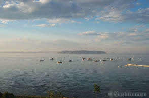
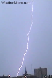
Lightning Strike Over
Portland, Maine
(image © Max Riseman)
This day featured numerous Severe Thunderstorm Warnings throughout the afternoon; the National Weather Service issued a Severe Thunderstorm watch that expired at 5:00PM. The rough weather came through Portland right around that time, with very heavy rain and much lightning. At our observation point near Back Cove, there was heavy rain as well as several very close lightning strikes. No hail or extreme winds were noted.
There were two lightning strikes in particular that were extremely close. I had my DV camcorder running during this time, and recorded both close strikes on tape; at least the flash and the resulting thunder. The first one was very loud, and sounded much like a gunshot or explosion; in this particular one, the windows of the car were closed. The second clip was taken from the window of my car, looking toward Portland in-town. The open windows allowed for a much nicer representation of the 'electric slap'. The sound map of this thunder's onset is below.
![]()
Thunder Sound Intensity Over Time
(from Sequence 2)
In calculating the approximate distance from us to the lightning strike, the frame time of the first sound (the 'slap') was used.
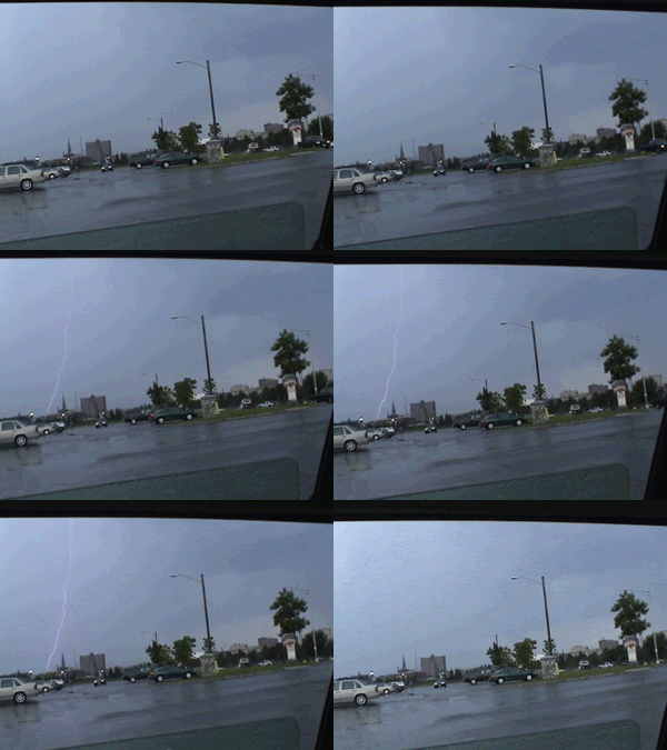
The photo at the top of this report is taken from a third movie sequence with three distinct bolts that were recorded on tape. The slow-motion animation link below shows the three strikes - they are not visible during the full-speed loop of sequence 3; only two were visible in the full-speed DV playback.
In an attempt (afterward) to figure out where the bolts in Sequence 1 and 2 hit, I used the time stamp on the camera, combined with the frame time of the flash and the frame time of the first hint of thunder from that stroke; relative positions of objects in the picture were used for timing. Weather values from Weather Maine (South Portland) were used to calculate the speed of sound. At 28°C/82°F and 85% Relative Humidity, the speed of sound is 350m/s. Combining that information with the timing of the video frames (1/2 to 3/4 second), I calculated that the approximate distance to the strike (at least the origin of the sound) to be between 500 and 850 ft (175m to 260m) away! Upon referencing a local topographical map (1:25000), I looked for recognizable buildings. Given the location of the buildings on the map, the apparent location of the flash in the footage, as well as the approx. 500ft between us and the strike, I surmise that both strikes hit the communications tower by Hannaford and Arby's, near Back Cove. It is unclear where the third sequence of strikes hit.
Movies: Sequence 1 | Sequence 2 | Sequence 3 (340Kbps WMV)
Animated GIF: 24 frames taken from the DV camcorder. There is approximately a 0.07 second interval between frames, 24 frames total. (654KB). This is a slow-motion shot of Sequence 3 above:
This movie is 15 minutes of video sped up to 16 times the recorded speed, or about 1 minute in duration. Taken at around 6:30 pm.
The audio track is removed. A few lightning strikes occurred within the field of view of the camera, but the speed of the loop masks the bolts. The strong storm that caused the clouds and weather moved to the North of Scarborough and Portland before sliding off the mid-coast. No rain was received at our observing location.
This footage was taken from just off Route 1 in Scarborough, Maine near the Scarborough Municipal building.
Moist, muggy air ahead of a stalled front sat over much of New England for the days around July 23, 2003. A persistent upper-level trough remains to the West of us, destabilizing the air and providing a Southwesterly flow aloft. Unstable air, combined with dewpoints at or above 70°F, means there is ample moisture in the air for heavy rain.
|
||||||||||||||||||||||||
Seabreeze on June 23, 2003
South Portland, Maine Weather Sensors
At around 1:15PM, a very distinct line of fog and a layer of stratus ("a wall of clouds") moved inland from the ocean obscuring the sun and substantially reducing visibility. The apparent humidity was high, and there was some very light surface misting occurring. The Fog and Stratus broke about 2 hours later. It appeared that the moisture from the fog was advected upward, inland, into a deck of stratocumulus that hung around until at least shortly after sunset.
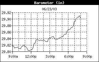 |
Barometer Jump begins at 12:00 Noon and rises from 29.805" to 29.836" at 12:50PM. The barometer is mostly steady for several hours after the Seabreeze front passage, then rises slowly into the evening.
|
|
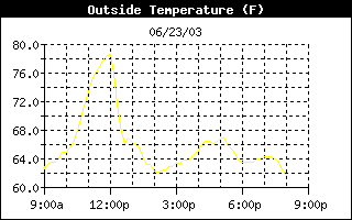 |
The temperature drops from 78.5°F at Noon to 66.8°F at 12:50PM; the temperature dropped almost 10 degrees F in the first 1/2 hour of the passage. Unlike the Barometer, the temperature keeps dropping, and ends up at 63.1°F at 1:40PM. Overall change is 11.7°F in 1 hour and 40mins. |
|
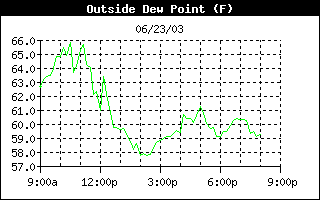 |
Dewpoint drops a bit earlier than the rest. It fluctuated around 65°F 1 hour preceding the event, and dropped 5°F in two hours. The dewpoint delta for this event is about 6°F The relative humidity jumped by 10% right after the frontal passage. |
|
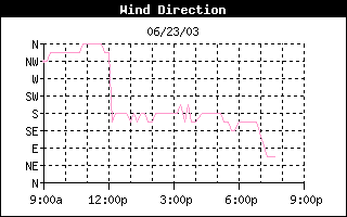 |
Definite wind shift from N and NNW to SSE and S. The winds were Northerly all morning long, then S or SSE after the seabreeze front passage. | |
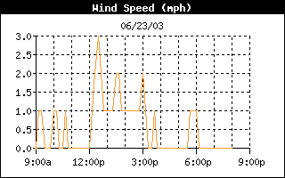 |
Graph shown to left is wind speed; the local topography affects wind speeds, so wind gust is used in this example. Wind (gust) picks up from 2 mph (during the hour preceding) to 6 mph during the hour following the sea breeze front passage. There is a marked increase in the overall wind speed as indicated by the graph. |
|
|
|
||
Tropical Storm Ana formed on April 21st and remained a tropical system until the 24th of April.
Ana had a maximum wind speed of 45 knots during its life. This is the first tropical system in the Atlantic ever recorded in April; records began in 1871.
You can get the Tropical Season (2003) history at Plymouth State University's Tropical Weather Pages.
 |